What was happening 100 years or more ago on the ground you are standing on right now? How did your town gets its name? Where did the street names in your neighbourhood come from? A little bit of research online or at your local library can provide you with a wealth of interesting information.
Here's some of the information I've discovered about the town where I grew up....
The main street was originally planned by Lieutenant-Governor John Graves Simcoe as a military road from York (Toronto) to Fort Penetanguishene. Surveying began in the spring of 1794 but the road was not fully opened until early 1796. Although Yonge Street was conceived as a military road, the possibilities for settlement along its length were obvious.
The village of Richmond Hill began about 1801 when Abner Miles, an innkeeper and merchant from York, settled on the lots each side of Yonge Street at Major Mackenzie Drive. He established an inn, store, and ashery, thus creating a nucleus for future development. On his death in 1806 his son James inherited his lands, eventually donating land for the Presbyterian Church and a school.
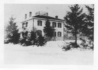
Above: Home built by James Miles (son of Abner Miles) at the southwest corner of Yonge Street and Major Mackenzie Drive, as it looked in 1885. The home was occupied for many years by Miles' nephew James Playter Jr., and later by the Boyle family. Unfortunately, the house is no longer there.
By 1830, the name 'Richmond Hill' had become well established. The village was known briefly as Miles Hill and then Mount Pleasant. According to popular history, 'Richmond Hill' may have come from a visit of the Duke of Richmond to the area, in 1819. However, the family of Benjamin Barnard believed that the name was adopted when their father taught his school classes to sing "The Lass of Richmond Hill", a favourite song from his childhood in Richmond, Surrey.
This is only the tip of the information I've found. There is so much more to discover. It might not be the most exciting stuff to you but I love history! You'll have to excuse me now, I'm off to do more research.

No comments:
Post a Comment